W
EST DRAYTON - UXBRIDGE VINE STREET


Opened - 8.9.1856
Closed to passengers - 10.9.1962
Closed to goods - 13.7.1964

Stations
-West Drayton 2nd (opened 1884) r/n 1895 West Drayton & Yiewesley r/n 1974 West Drayton
-West Drayton 1st (opened 1838, closed 1884)
-Cowley (opened 1904)
-Uxbridge r/n 1907 Uxbridge Vine Street

Motive Power Depots Uxbridge one-track shed (closed 1897).

History
Uxbridge lies 16 miles west of the centre of London and the first railway to reach the market town was the Great Western & Uxbridge Railway (GW&UR) in 1856. Laid to the broad gauge the single line left the Paddington - Reading main line at West Drayton. The GW&UR was absorbed by the GWR the following year; they converted it to standard gauge in 1881 and doubled it in 1880. In 1950 the Western Region ran a shuttle service of about two trains and hour with the 2_ miles covered in seven minutes. Passenger services were withdrawn in September 1962 and the following month it was re-singled. Goods traffic only lasted a further two years and it closed to all traffic in 1964 with track lifted within twelve months.


Route - when open
The bay platform at the west end of West Drayton station (GR061801) was used by both Uxbridge and Staines branch trains with both branches diverging NW from the Paddington - Reading line immediately west of the bridge over High Street. The two branches then parted company after a short distance with this line turning north to pass over the Grand Union Canal, over High Road (A408) and under Station Road at Cowley station. It continued north alongside Cleveland Road, under The Greenway, and then alongside Whitehall Road to reach the terminus station at Uxbridge Vine Street (GR056839).


Route - today
Earthworks have been removed and little of the trackbed remains. The cutting alongside Brunel University has been infilled for use as gardens and playing fields but a section has been left as a nature reserve and this contains a relaid section of GWR broad gauge trackwork.


Relics
West Drayton station (2nd) - still open (Paddington - Reading line)
West Drayton station (1st) - demolished: no trace
Cowley station - demolished: no trace
Uxbridge Vine Street station - demolished: site occupied by a new block of offices.
Bridges - all bridges removed or infilled.
Uxbridge loco shed (GR056839) on east side of Vine Street station - demolished


(The above text courtesy of
Ralph Rawlinson. ©2005.)


Looking northward from the Greenway at the route of the line adjacent to Whitehall Road. The cutting has been utilised here to provide low level car parking.

(photo: 2008)


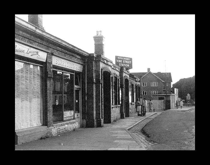
Looking north at the approach to Vine St station from the Manor Waye footbridge south of the station.

photo: Phil Reeks. ©1962


Looking northward at the platform area of Vine Street station. The platforms were located where the yellow brick Hertz building is, in a more or less direct line from the camera's position. The southern end of the platform area has been cut through by the Uxbridge by-pass (Hillingdon Road), as seen here.

The goods yard was situated on the left, where the dual carriageway is now.

(photo: 2008)


Chris Totty's 1965 photograph of the rear of the station.

#1 - is the block of the flats on Hillingdon Rd (still extant today)
#2 - is the goods yard
#3 - the station itself
#4 - the buildings between the station and Cricket Field Road.


The goods yard, the station, and the buildings between the station and Cricket Field Road each occupy about a third of the distance between Whitehall Road (as it was) and Cricket Field Road. The new Hertz building occupies the middle third.


An aerial image courtesy of Google Earth, showing the station's area:

#1 - is the block of the flats on Hillingdon Rd
#2 - is the original alignment of Whitehall Road
#3 - Cricket Field Road
#4 - the buildings between the station and Cricket Field Road
#5 - the platform area


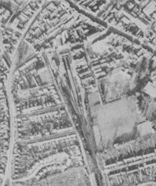
Aerial views from 1945 and 2010, both courtesy of Google Earth, distinctly showing the position of the station in relation to the area today. The station is more or less centre of the image.

Move your cursor over the image to toggle between the images.


The southern end of the platforms at Vine Street.

photo: Phil Reeks. ©1962


photo: Phil Reeks. ©1962


Vine Street station building as photographed by Chris Totty in 1962. Move your cursor over the image to see the same view in 2008. The only reference point between the two photos is the block of flats on Hillingdon Rd on the right of the photo.

Chris Totty's photograph also appears on the Uxbridge Vine Street station page of Nick Catford's Disused Stations website.


A view the opposite way showing Hertz House. This was built on the site of the platforms. The dual carriageway Uxbridge by-pass (Hillingdon Road) is to the right of the photo, out of shot.

(photo: 2008)


More Uxbridge Vine Street station photos:

www.disused-stations.org.uk


Original research for this page by Roderick Timmerman.


Uxbridge High Street - Denham